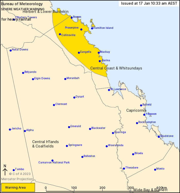
Source: Bureau of Meteorology
For people in Central Coast and Whitsundays and parts of Herbert and Lower Burdekin Forecast Districts.
Issued at 10:33 am Tuesday, 17 January 2023.
Heavy to locally intense rainfall remains possible over areas between Ayr and St Lawrence.
Weather Situation: A broad low pressure trough north of the Whitsundays and an area of strong convergence to its south will begin slowly moving north today. The trough and heavier rain are expected to move offshore by Wednesday morning.
HEAVY RAINFALL which may lead to FLASH FLOODING remains possible over the Central Coast and Whitsundays today, but will begin to shift offshore to the north late in the day. Six-hourly rainfall totals between 100 to 180 mm are possible with isolated 24-hourly totals up to 300 mm. Over the southeastern Herbert and Lower Burdekin district, six-hourly rainfall totals between 80 to 120 mm are possible.
Locally INTENSE RAINFALL which may lead to DANGEROUS AND LIFE-THREATENING FLASH FLOODING is also possible over of the Central Coast and Whitsundays. Six-hourly rainfall totals between 200 to 250 mm are possible, particularly about the coast and ranges north of about Mackay to Nebo. A separate Severe Thunderstorm Warning will be issued if very dangerous thunderstorms with intense rainfall are detected.
A broad Flood Watch and multiple Flood Warnings are current for the area covered by this Severe Weather Warning.
Locations which may be affected include Mackay, Proserpine, Bowen, Collinsville, Hamilton Island, Sarina, Nebo, Eungella and Airlie Beach.
Severe weather is no longer occurring in the Central Highlands and Coalfields district and the warning for this district is CANCELLED.
Significant 24-hourly rainfall observations to 9 am AEST Monday include:
392 mm at Jubilee Pocket
372 mm at Peter Faust Dam
317 mm at Proserpine Airport
313 mm at Preston and Bowen
Significant 24-hourly rainfall observations to 9 am AEST Tuesday include:
360 mm at Finch Hatton
320 mm at Ridgelands
308 mm at Eungella
Queensland Fire and Emergency Services advises that people should:
* Never drive, walk or ride through flood waters. If it's flooded, forget it.
* Keep clear of creeks and storm drains.
* For emergency assistance contact the SES on 132 500.


No comments:
Post a Comment