Source: Bureau of Meteorology
Issued at 1:13 pm EST on Monday 16 January 2023 Flood Watch Number: 5
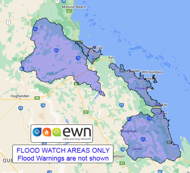
MINOR TO MODERATE FLOODING WITH ISOLATED MAJOR FLOODING POSSIBLE ACROSS THE FLOOD WATCH AREA
A trough extends across northern Queensland to a weak tropical low near the Herbert and Lower Burdekin coast. The low will drift southward along the east coast towards the Whitsunday Islands over the next day or two enhancing rainfall in its vicinity. The tropical low may move east offshore, while the trough is likely to move northwards and become more monsoonal from Wednesday.
Catchments across the flood watch area are wet to saturated from recent rainfall and are likely to respond relatively quickly to further rainfall.
Areas of heavy to locally intense rainfall across the flood watch area are likely. Successive days of heavy rainfall are likely over some areas. A Severe Weather Warning for heavy rainfall is current for Central Coast and Whitsundays and parts of Herbert and Lower Burdekin and Central Highlands and Coalfields Forecast Districts.
Heavy rainfall is expected to continue over coastal areas between Townsville and Carmila, and potentially over adjacent inland areas.
Minor to moderate flooding is possible across the flood watch catchments, with isolated major flooding possible. Heavy rainfall, possibly intense at times, may cause localised flooding, including flash flooding. Disruption to transport routes is likely across parts of the Flood Watch area.
Catchments likely to be affected include:
Black River (including Bluewater Creek)
Ross and Bohle Rivers
Burdekin River to Burdekin Falls Dam (Flood warnings are current for other
parts of the catchment)
Don and Proserpine Rivers (A major flood warning is current for the Don
River)
Connors, Isaac and Styx Rivers and Plane Creek (A moderate flood warning is
current for the Connors-Isaac Rivers)
Flooding warnings are current in the following catchments: Upper and Lower Flinders River, Haughton River, Cape River to Burdekin Falls Dam, Belyando and Suttor Rivers to Burdekin Falls Dam and Burdekin River downstream of Burdekin Falls Dam, Pioneer River, and Comet and Nogoa Rivers,
See www.bom.gov.au/qld/warnings to view the current flood and cyclone products for Queensland.
For more information on the Flood Watch Service:
http://www.bom.gov.au/water/floods/floodWarningServices.shtml
Flood Safety Advice:
This Flood Watch means that people living or working along rivers and creeks should monitor the latest weather forecasts and warnings.
Remember: If it's flooded, forget it.
For flood emergency assistance contact the SES on 132 500.
For life threatening emergencies, call Triple Zero (000) immediately.
Current emergency information is available at www.qld.gov.au/alerts.
This advice is also available by dialling 1300 659 219 at a low call cost of
27.5 cents, more from mobile, public and satellite phones.
Warning, rainfall and river information are available at www.bom.gov.au/qld/flood/
Rainfall and River Conditions Map


No comments:
Post a Comment