Source: Bureau of Meteorology
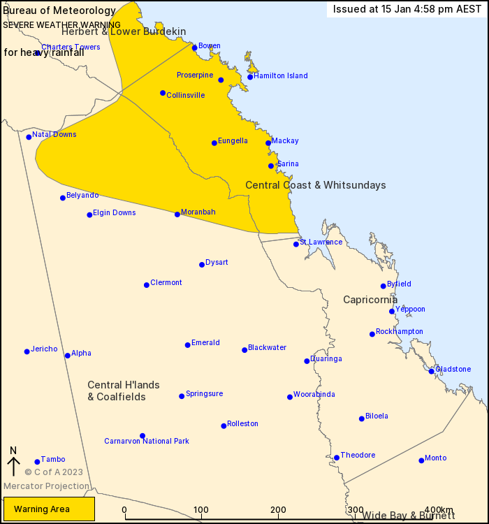
For people in Central Coast and Whitsundays and parts of Herbert and Lower Burdekin and Central Highlands and Coalfields Forecast Districts.
Issued at 4:58 pm Sunday, 15 January 2023.
Heavy rainfall over areas between Ayr and Carmila, and potentially over the northern Central Highlands.
Weather Situation: A broad low pressure system about the Herbert and Lower Burdekin coast and an area of strong convergence to its south over the Central Coast and Whitsundays will remain slow-moving for the remainder of today and through Monday.
HEAVY RAINFALL which may lead to FLASH FLOODING is forecast to continue for the remainder of today and through Monday over parts of the Herbert and Lower Burdekin, and Central Coast and Whitsundays districts. Six-hourly rainfall totals between 100 to 180 mm are likely with isolated 24-hourly totals up to 300 mm. Over northern parts of the Central Highlands and Coalfields district, six-hourly rainfall totals between 80 to 120 mm are possible from Monday morning with isolated 24-hourly totals up to 150 mm.
Locally INTENSE RAINFALL which may lead to DANGEROUS AND LIFE-THREATENING FLASH FLOODING is also possible over far southeastern parts of the Herbert and Lower Burdekin, and the Central Coast and Whitsundays from later tonight and through Monday. Six-hourly rainfall totals between 200 to 250 mm with 24-hourly totals up to 400 mm are possible, particularly about the coast and ranges north of Mackay. A separate Severe Thunderstorm Warning will be issued if very dangerous thunderstorms with intense rainfall are detected.
Although widespread heavy rainfall has eased north of Ayr, isolated severe thunderstorms with locally heavy rainfall remains possible across the northeast tropics, including the Townsville area.
A broad Flood Watch and multiple Flood Warnings are current for the area covered by this Severe Weather Warning.
Locations which may be affected include Mackay, Proserpine, Bowen, Collinsville, Hamilton Island, Sarina, Ayr, Nebo, Eungella, Airlie Beach and Clare.
Significant rainfall observations in the 24 hour period to 9 am AEST Sunday include:
271 mm at Upper Finch Hatton.
256 mm at Finch Hatton.
234 mm at Hamilton Island.
224 mm at Rollingstone.
210 mm at South Townsville
Queensland Fire and Emergency Services advises that people should:
* Never drive, walk or ride through flood waters. If it's flooded, forget it.
* Keep clear of creeks and storm drains.
* For emergency assistance contact the SES on 132 500.


No comments:
Post a Comment