
Source: Bureau of Meteorology
TROPICAL CYCLONE ADVICE NUMBER 11
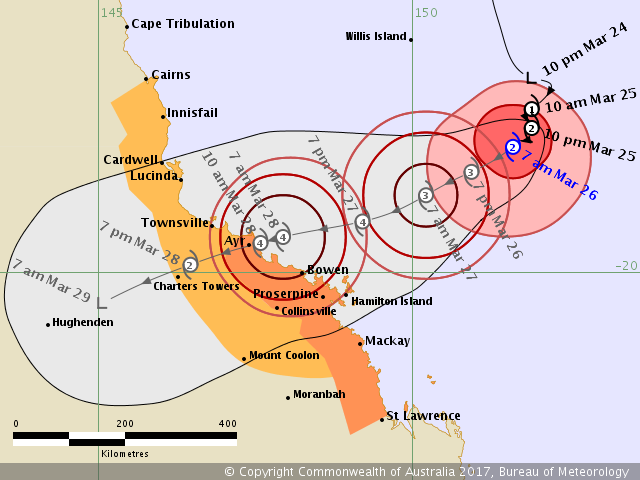
Issued at 7:38 am EST on Sunday 26 March 2017
Headline:
Tropical cyclone Debbie expected to intensify into a category 3 system today.
Areas Affected:
Warning Zone
Ayr to St Lawrence including Bowen, Mackay, and the Whitsunday Islands.
Watch Zone
remaining coastal areas from Cairns to Ayr including Innisfail and Townsville, extending inland to Charters Towers and Mount Coolon.
Cancelled Zone
None.
Details of Tropical Cyclone Debbie at 7:00 am AEST:
Intensity: Category 2, sustained winds near the centre of 100 kilometres per hour with wind gusts to 140 kilometres per hour.
Location: within 35 kilometres of 18.0 degrees South 151.6 degrees East, estimated to be 525 kilometres east northeast of Townsville and 475 kilometres east northeast of Ayr.
Movement: slow moving.
Tropical cyclone Debbie is starting to adopt a west-southwest track towards the north Queensland coast and is currently forecast to intensify into a category 3 system this afternoon. Tropical cyclone Debbie is likely to intensify further prior to making landfall between Lucinda and the area north of Mackay on Tuesday morning.
Hazards:
GALES are expected to develop about the exposed coast and islands between Ayr and Mackay during this afternoon or evening, and could extend further south to St Lawrence tonight. GALES could extend further north to coastal areas between Cairns and Ayr on Monday or during Tuesday morning, as well as further inland to Charters Towers and Mount Coolon.
DESTRUCTIVE WINDS with gusts over 125 km/h may develop about the exposed coast and islands between Ayr and Mackay as early as Monday morning, before extending further north to Lucinda by the evening.
The VERY DESTRUCTIVE CORE of Tropical Cyclone Debbie is currently expected to cross the coast between Townsville and Proserpine on Tuesday morning, most likely as a CATEGORY 4 tropical cyclone, with wind gusts up to 260 km/h near the centre.
Abnormally high tides are expected to occur between at least Lucinda and Mackay as the cyclone approaches the coast. Large waves may also develop along the beachfront. People living in areas likely to be affected by this flooding should take measures to protect their property as much as possible and be prepared to follow instructions regarding evacuation of the area if advised to do so by the authorities.
Areas of heavy rain with the potential to cause severe flash flooding are expected to develop about parts of the northern and central Queensland coast and adjacent inland areas late on Sunday and continue through Monday and Tuesday. Major river flooding may also develop over a broad area next week and a Flood Watch is current for coastal catchments between Cairns and Gladstone, extending inland to the eastern Gulf River catchments.
Recommended Action:
People between Ayr and St Lawrence should immediately commence or continue preparations, especially securing boats and property using available daylight hours.
- For cyclone preparedness and safety advice, visit Queensland's Disaster Management Services website (www.disaster.qld.gov.au)
- For emergency assistance call the Queensland State Emergency Service on 132 500 (for assistance with storm damage, rising flood water, fallen trees on buildings or roof damage).
People between Cairns and Ayr, and inland to Charters Towers and Mount Coolon should consider what action they will need to take if the cyclone threat increases.
- Information is available from your local government
- For cyclone preparedness and safety advice, visit Queensland's Disaster Management Services website (www.disaster.qld.gov.au)
- For emergency assistance call the Queensland State Emergency Service on 132 500 (for assistance with storm damage, rising flood water, fallen trees on buildings or roof damage).
Current Tropical Cyclones
 |


No comments:
Post a Comment