
Source: Bureau of Meteorology
TROPICAL CYCLONE ADVICE NUMBER 6
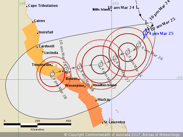
Issued at 4:54 pm EST on Saturday 25 March 2017
Headline:
Tropical Cyclone Debbie has formed in the Coral Sea.
Areas Affected:
Warning Zone
Ayr to St Lawrence, including Bowen, Mackay and the Whitsunday Islands.
Watch Zone
Cairns to Ayr, including Cardwell and Townsville.
Cancelled Zone
Cape Tribulation to Cairns.
Details of Tropical Cyclone Debbie at 4:00 pm AEST:
Intensity: Category 1, sustained winds near the centre of 65 kilometres per hour with wind gusts to 95 kilometres per hour.
Location: within 55 kilometres of 17.5 degrees South 151.8 degrees East, estimated to be 640 kilometres east of Cairns and 560 kilometres east northeast of Townsville.
Movement: slow moving.
Tropical Cyclone Debbie is currently a category 1 cyclone, but is continuing to show signs of development. The system has been relatively slow moving during today, but is expected to adopt a steady west-southwest track in the next few hours. This general west-southwesterly motion is expected to continue for the next few days, bringing the cyclone towards and eventually onto the north Queensland coast. Conditions are expected to favour the continued intensification of the cyclone as it approaches the coast over the weekend and into early next week.
Hazards:
Tropical Cyclone Debbie is expected to cross the coast between Townsville and Proserpine on Tuesday morning, most likely as a CATEGORY 4 tropical cyclone, with wind gusts up to 260 kilometres per hour near the centre.
DESTRUCTIVE winds are likely to develop about the Whitsunday Islands and nearby coast on Monday evening, and extend to other areas between Ayr and Mackay overnight into Monday morning.
GALES are expected to develop between Ayr and St Lawrence from late Monday afternoon and evening, and may extend to other coastal areas north to Innisfail during Tuesday.
Based on the current forecast track, abnormally high tides are expected to occur between at least Lucinda and Mackay as the cyclone approaches the coast. Large waves may also develop along the beachfront.
Areas of heavy rain are expected to develop about parts of the northern and central Queensland coast and adjacent inland areas into Sunday. A Flood Watch is current for coastal catchments between Cooktown and Mackay, extending inland to the eastern Gulf River catchments.
Recommended Action:
Recommended Action:
- People between Ayr and St Lawrence should immediately commence or continue preparations, especially securing boats and property [using available daylight hours/before nightfall].
- People between Cairns and Ayr should consider what action they will need to take if the cyclone threat increases.
- For cyclone preparedness and safety advice, visit Queensland's Disaster
Management Services website (www.disaster.qld.gov.au)
- For emergency assistance call the Queensland Fire and Emergency Service
(QFES) on 132 500 (for assistance with storm damage, rising flood water, fallen
trees on buildings or roof damage)
Current Tropical Cyclones
 |


No comments:
Post a Comment