QLD Severe Weather Warning: Locally Destructive Winds
Source: Bureau of Meteorology
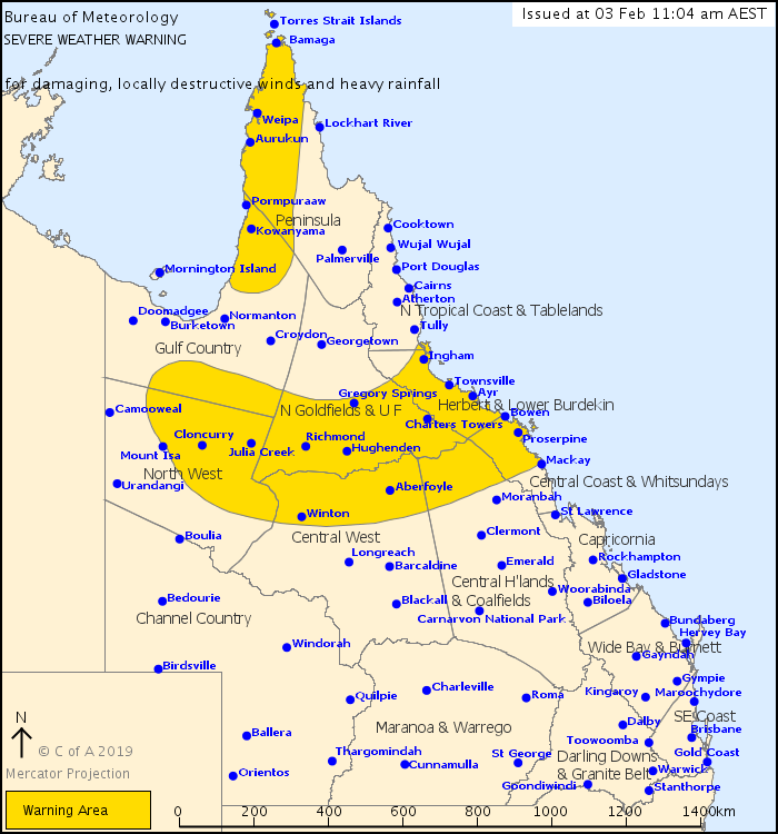
For people in Herbert and Lower Burdekin, Central Coast and Whitsundays and parts of Peninsula, Gulf Country, North Tropical Coast and Tablelands, Northern Goldfields and Upper Flinders, North West, Central Highlands and Coalfields and Central West Forecast Districts.
Issued at 11:04 am Sunday, 3 February 2019.
DAMAGING GUSTS AND INTENSE RAINFALL WITH SIGNIFICANT FLASH FLOODING EXPECTED BETWEEN INGHAM TO BOWEN, SLOWLY EXTENDING SOUTH. Threat for heavy rainfall and damaging winds remains elsewhere.
Weather Situation: A slow-moving monsoon trough lies across north Queensland, extending from Townsville to Gregory Springs and into central parts of the Northern Territory. It is forecast to shift slowly south over the next day or two to be near Bowen to Hughenden and into the Gulf Country. A deep, semi-stationary tropical low is also embedded along the monsoon trough, currently located about 200km north-northeast of Mt Isa. The monsoon flow is expected to continue intensifying for the remainder of today resulting in widespread severe weather.
The monsoon trough is expected to remain active this week, with further heavy rainfall expected for already saturated catchments. The potential for significant and dangerous flash flooding will likely continue for areas between Ingham and Bowen, extending as far south as Mackay from Monday.
HERBERT AND LOWER BURDEKIN AND CENTRAL COAST DISTRICTS including TOWNSVILLE, INGHAM, BOWEN, AYR, PALM ISLAND, GIRU, ROLLINGSTONE, PROSERPINE AND WHITSUNDAY ISLANDS:
Over the next 24 to 30 hours, heavy rainfall with six-hourly rainfall totals between 150mm to 200mm are likely with concentrated areas of intense rainfall with totals up to 300mm possible, particularly with bands of thunderstorms.
Creek and river catchments are already saturated and will therefore respond very rapidly to any rainfall. Flash flooding is a high risk. Landslides have been reported associated with this event and will continue to be possible in vulnerable areas that have experienced significant rainfall.
Damaging wind gusts up to 100km/h are also possible about the coast and ranges, potentially locally destructive in excess of 125km/h in thunderstorms.
A number of major Flood Warnings are current for this region - please refer to http://www.bom.gov.au/qld/warnings/
92km/h wind gust was recorded at Lucinda at 9pm AEST.
24 hours rainfall to 9am Sunday:
Ingham Pump Station 506mm, Halifax 416mm Gairloch 414mm, Cardwell Gap 309mm Mount Margaret 232mm, South Townsville 226mm and Mount Bradley 154mm.
REMAINING PENINSULA, GULF COUNTRY AND INLAND AREAS. Locations which may be affected include CHARTERS TOWERS, CLONCURRY, WINTON, HUGHENDEN, KOWANYAMA, WEIPA AND TORRES STRAIT ISLANDS:
Over the next 24 to 30 hours, heavy rainfall, which may lead to localised flash flooding, is expected over parts of the Gulf Country (south of Pormpuraaw), North West, Central West and Northern Goldfields and Upper Flinders districts. Six-hourly rainfall totals of 70 to 120mm are possible.
Damaging wind gusts up to 100km/h are also possible to the south of the monsoon trough and tropical low. Monsoonal squalls with gusts up to 90km/h may also develop north of Pormpuraaw, particularly with thunderstorms.
Flood Warnings are current for this region - please refer to http://www.bom.gov.au/qld/warnings/
24 hours rainfall to 9am Sunday:
Gereta Station 232mm, Julius Dam 204mm, Gunpowder 145mm, Miranda Creek 138mm, Dugald River 128mm and Cloncurry 106mm.
The warning has been cancelled for parts of the North West district and northern interior, including Mount Isa, Georgetown and Croydon.
Queensland Fire and Emergency Services advises that people should:
* Move your car under cover or away from trees.
* Secure loose outdoor items.
* Seek shelter, preferably indoors and never under trees.
* Beware of fallen trees and powerlines.
* Never drive, walk or ride through flood waters. If it's flooded, forget it.
* Keep clear of creeks and storm drains.
* For emergency assistance contact the SES on 132 500.
 |


 Help | Log In | Alerts Map | Register | Unsubscribe
No comments:
Post a Comment