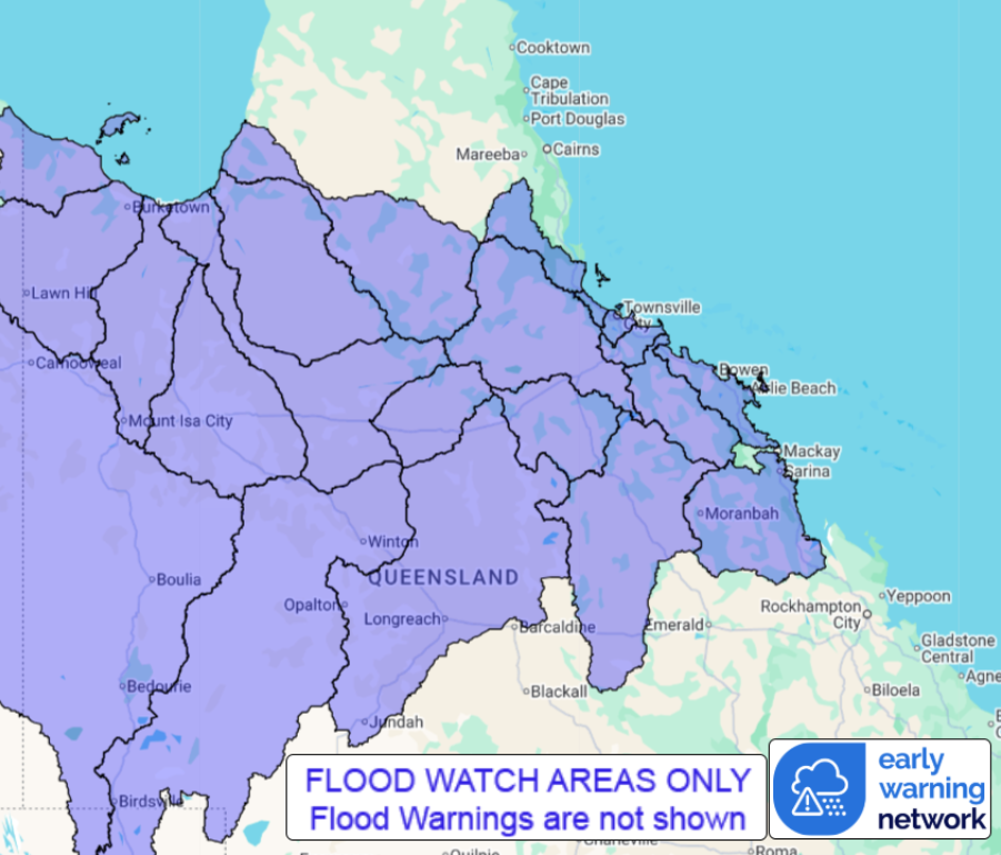
| | QLD Flood Watch: Parts of North-Western Queensland and Northeast Tropical Coast | Source: Bureau of Meteorology
Flood Watch for parts of North-Western Queensland and Northeast Tropical Coast
Issued at 11:56 am AEST on Friday 26 December 2025
Flood Watch Number: 5
Correct Title of Flood Watch
FLOODING POSSIBLE IN PARTS OF NORTHWESTERN QUEENSLAND FROM TODAY, BECOMING MORE LIKELY FROM SUNDAY, AND EXTENDING TO THE NORTHEAST TROPICAL COAST FROM SUNDAY
A tropical low embedded in the monsoon trough lying through northwest Queensland is expected to deepen and slowly drift south east over the weekend. This low and trough will combine with deep tropical moisture to produce scattered showers and thunderstorms with isolated heavy falls Friday and Saturday, before rainfall becomes widespread and potentially intense from Sunday, and continues into next week.
Along the east coast, a coastal trough will move north and become slow moving from Sunday between Ayr and Cairns, producing prolonged heavy rainfall along the coast. The exact location of the heaviest falls remains uncertain and will depend on the location of the trough.
River level rises are occurring in some northwest Queensland catchments with flooding possible from Saturday. On Sunday, heavy to intense rainfall may cause rapid and dangerous river level rises in Gulf catchments and upper parts of the Georgina and Diamantina Rivers.
Heavy rainfall may also cause rapid river level rises along the Northeast Tropical Coast from Sunday.
Catchments are increasingly wet following recent rainfall.
River and creek level rises, overland flow, and isolated flooding in low-lying areas are possible across many inland parts of the Flood Watch area. Riverine flooding is possible from Saturday in north west Queensland with road closures and community isolation likely. Riverine flooding is expected to extend to the Northeast Tropical Coast from Sunday.
Catchments likely to be affected include:
Herbert River
Black River
Ross and Bohle Rivers
Haughton River
Belyando and Suttor Rivers to Burdekin Falls Dam
Cape River to Burdekin Falls Dam
Burdekin River to Burdekin Falls Dam
Burdekin River downstream of Burdekin Falls Dam
Don and Proserpine Rivers
Connors, Isaac and Styx Rivers and Plane Creek
Settlement Creek
Nicholson River
Leichhardt River
Upper Flinders River
Lower Flinders River
Cloncurry River
Norman River
Gilbert River
Georgina River and Eyre Creek(rainfall expected mainly in upper catchment)
Diamantina River(rainfall expected mainly in upper catchment)
Thomson River(rainfall expected mainly in upper catchment)
Flood Warnings are current for the following catchment(s): Baffle
For the latest flood and weather warnings see www.bom.gov.au/weather-and-climate/warnings-and-alerts
For the latest rainfall and river level information see www.bom.gov.au/australia/flood
Safety Advice:
Don't drive, walk, swim or play in floodwater because it is dangerous.
Stay away from flooded drains, rivers, streams and waterways.
Obey road closure signs. Plan ahead so you don't drive on flooded roads.
Check the ABC and local media for updates. The situation can change quickly, so stay informed.
For local emergency management warnings and advice visit www.disaster.qld.gov.au/warnings.
For emergency assistance call SES on telephone number 132 500. In life-threatening emergencies, call 000 (triple zero) immediately.
Rainfall and River Conditions Map
 |


No comments:
Post a Comment