| | QLD Tropical Cyclone Warning: Innisfail to Sarina, including Townsville, Mackay, Bowen, Whitsunday Islands, extending inland to Charters Towers |
Source: Bureau of Meteorology
Issued at 9:58 am EST on Thursday 25 January 2024
Headline:
Tropical Cyclone Kirrily to cross the coast near Townsville tonight. Gales now occurring over Whitsunday Islands, to extend to the mainland today.
Areas Affected:
Warning Zone
Innisfail to Sarina, including Townsville, Mackay, Bowen, the Whitsunday Islands, and extending inland to Charters Towers.
Watch Zone
None.
Cancelled Zone
None.
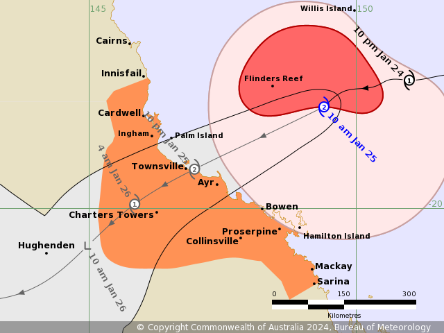
Details of Tropical Cyclone Kirrily at 10:00 am AEST:
Intensity: Category 2, sustained winds near the centre of 95 kilometres per hour with wind gusts to 130 kilometres per hour.
Location: within 35 kilometres of 18.1 degrees South 149.4 degrees East, estimated to be 305 kilometres east northeast of Townsville and 335 kilometres north of Mackay.
Movement: west southwest at 15 kilometres per hour.
Tropical Cyclone Kirrily is expected to continue strengthening as it tracks west southwest towards the Queensland coast. Kirrily will cross the Queensland coast tonight, in the vicinity of Townsville, as a Category 2 system then weaken on Friday as it moves inland.
From Friday, Kirrily is likely to track further inland as a tropical low, resulting in heavy to intense rain to parts of the northern interior and western Queensland.
Hazards:
GALES with DAMAGING WIND GUSTS to 120 km/h are occurring over the Whitsunday Islands and are expected to extend to mainland communities between Ayr and Sarina during the late morning. GALES with DAMAGING WIND GUSTS to 120 km/h are expected to extend northward to coastal and island communities between Ayr and Ingham, including Townsville, during this afternoon and evening and may extend north between Ingham to Innisfail if the system takes a track further north.
DESTRUCTIVE WIND GUSTS to 140 km/h may develop about coastal and island communities between Ayr and Bowen, during this evening extending north to Ingham, including Townsville tonight.
GALES with DAMAGING WIND GUSTS to 90 km/h are expected to extend to inland areas including Charters Towers overnight tonight into Friday morning.
HEAVY RAINFALL which may lead to FLASH FLOODING is likely to develop about coastal areas between Innisfail and Sarina during the day before spreading to inland areas late today and continuing during Friday. INTENSE RAINFALL which may lead to DANGEROUS AND LIFE THREATENING FLASH FLOODING is possible near the track of the system, most likely with the coastal crossing during tonight and Friday. A flood watch is also current for these areas.
During Friday, the system is expected to become a tropical low and HEAVY RAINFALL may develop across the northern interior and western Queensland into the weekend as the system tracks inland.
As the system approaches and crosses the coast, a STORM TIDE is expected between Townsville and Mackay. Large waves may produce minor flooding along the foreshore. People living in areas likely to be affected by this flooding should take measures to protect their property as much as possible and be prepared to help their neighbours.
Recommended Action:
People between Ingham and Bowen, including Townsville and Ayr should complete preparations quickly and be prepared to shelter in a safe place.
- Boats and outside property should be secured using available daylight hours.
- For cyclone preparedness and safety advice, visit Queensland's Disaster Management Services website (www.disaster.qld.gov.au)
- For emergency assistance call the Queensland State Emergency Service (SES) on 132 500 (for assistance with storm damage, rising flood water, fallen trees on buildings or roof damage).
- If you choose to take shelter away from your home, stay COVID-19 safe and pack a mask and hand sanitiser (if you have them).
People between Innisfail and Ingham and between Bowen and Sarina, including Bowen, Mackay, and the Whitsunday Islands, should immediately commence or continue preparations, especially securing boats and property using available daylight hours.
People in inland areas to Charters Towers should take precautions and listen to the next advice.
- Information is available from your local government
- For cyclone preparedness and safety advice, visit Queensland's Disaster Management Services website (www.disaster.qld.gov.au)
- For emergency assistance call the Queensland State Emergency Service (SES) on 132 500 (for assistance with storm damage, rising flood water, fallen trees on buildings or roof damage).
- If you choose to take shelter away from your home, stay COVID-19 safe and pack a mask and hand sanitiser (if you have them).
Current Tropical Cyclones
|


No comments:
Post a Comment