| | QLD Tropical Cyclone Warning: Ayr to Mackay, including Mackay, Bowen and the Whitsunday Islands |
Source: Bureau of Meteorology
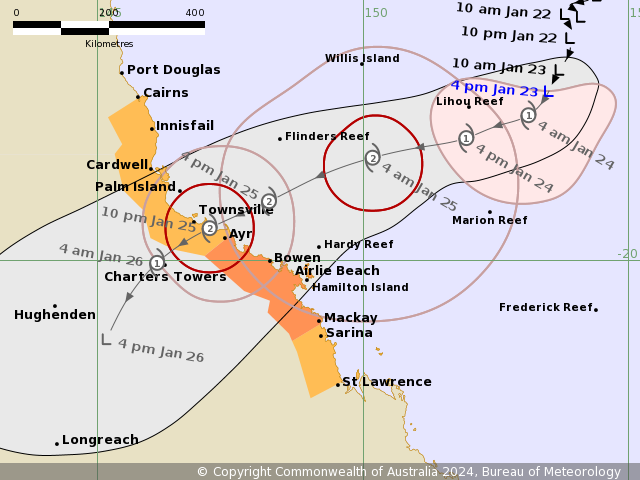
Issued at 4:44 pm EST on Tuesday 23 January 2024
Headline:
Tropical cyclone impacts likely to begin for coastal and Island communities from Wednesday afternoon.
Areas Affected:
Warning Zone
Ayr to Mackay, including Mackay, Bowen and the Whitsunday Islands.
Watch Zone
Cairns to Ayr (not including Cairns), including Townsville. Mackay to St Lawrence.
Cancelled Zone
None.
Details of Tropical Low at 4:00 pm AEST:
Intensity: Tropical Low, sustained winds near the centre of 65 kilometres per hour with wind gusts to 95 kilometres per hour.
Location: within 55 kilometres of 16.8 degrees South 153.5 degrees East, estimated to be 380 kilometres east of Willis Island and 760 kilometres east northeast of Townsville.
Movement: south southwest at 8 kilometres per hour.
A tropical low (05U) is developing slowly in the central Coral Sea and is expected to become a tropical cyclone tonight or early Wednesday. This system is forecast to track southwest, towards the Queensland coast, over the next few days as it intensifies. The system is likely to cross the Queensland coast late Thursday between Cardwell and Airlie Beach as a Category 2 system.
In the longer term, the system is likely to track inland and south as a deep tropical low bringing heavy to intense rain to parts of central, western and southern Queensland.
Hazards:
GALES with DAMAGING WIND GUSTS to 120 km/h are likely to develop about the Whitsunday Islands from late Wednesday afternoon, they may extend to mainland communities between Townsville and St Lawrence overnight Wednesday into Thursday morning. GALES with DAMAGING WIND GUSTS to 120 km/h may extend northward to coastal and island communities between Cairns and Townsville during Thursday.
DESTRUCTIVE WIND GUSTS to 155 km/h may develop about coastal and island communities between Cardwell and Proserpine including Townsville and the Whitsunday Islands during Thursday.
HEAVY RAINFALL which may lead to FLASH FLOODING is likely to develop about coastal areas between Innisfail and St Lawrence from early Thursday before spreading to inland areas later during Thursday and continuing during Friday. INTENSE RAINFALL which may lead to DANGEROUS AND LIFE THREATENING FLASH FLOODING is possible near and south of the system, most likely with the coastal crossing during Thursday. A flood watch is also current for these areas.
During Friday, the system is expected to become a deep tropical low and HEAVY RAINFALL may develop across central, western and southern Queensland into the weekend as the system tracks inland and then south.
As the system approaches and crosses the coast, a STORM TIDE is expected between Townsville and Mackay. Large waves may produce minor flooding along the foreshore. People living in areas likely to be affected by this flooding should take measures to protect their property as much as possible and be prepared to help their neighbours.
Recommended Action:
People between Cairns to Ayr (not including Cairns), including Townsville. Mackay to St Lawrence, should consider what action they will need to take if the cyclone threat increases.
People between Ayr to Mackay, including Mackay, Bowen and the Whitsunday Islands should take precautions and listen to the next advice.
- Information is available from your local government
- For cyclone preparedness and safety advice, visit Queensland's Disaster Management Services website (www.disaster.qld.gov.au)
- For emergency assistance call the Queensland State Emergency Service (SES) on 132 500 (for assistance with storm damage, rising flood water, fallen trees on buildings or roof damage).
Current Tropical Cyclones
|


No comments:
Post a Comment