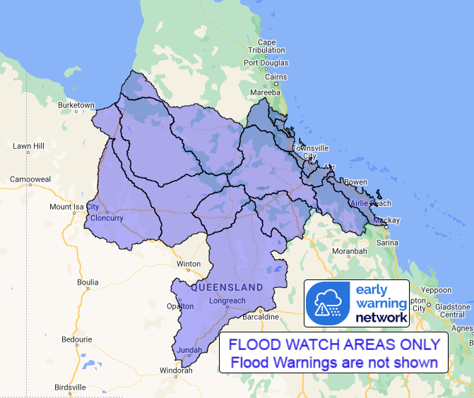
| | QLD Flood Watch: Catchments Between Tully and Airlie Beach, and Parts of the Central West and Gulf Catchments |
Source: Bureau of Meteorology
ssued at 12:59 pm EST on Wednesday 24 January 2024
Flood Watch Number: 3
MINOR TO MAJOR FLOODING POSSIBLE ACROSS COASTAL CATCHMENTS FROM THURSDAY INTO FRIDAY, RISK EXTENDING INLAND OVER THE WEEKEND
A tropical low in the northern Coral Sea is likely to develop into a Tropical Cyclone and move towards the Queensland coast over the next few days.
Widespread heavy to locally intense rainfall is likely across the Flood Watch area from Thursday morning. As the Tropical Cyclone approaches the coast, abnormally high tides are likely.
From Friday, the system is likely to track further inland as a tropical low, bringing heavy to locally intense rain to parts of the northern interior of Queensland and western Queensland, with a much reduced risk of flooding to southern Queensland. The area covered by the Flood Watch will be reassessed and updated daily based on the latest rainfall forecasts.
Catchments across the North Tropical Coast, and the Norman and Gilbert catchments, are wet following rainfall over recent weeks, whilst catchments further south and inland within the Flood Watch area are significantly drier.
Widespread rainfall is likely across coastal catchments within the Flood Watch area from Thursday morning, extending inland over the coming days.
Refer to the Tropical Cyclone Advice for the latest information on the developing tropical cyclone.
River level rises, including minor to major riverine flooding, are possible from late Thursday across coastal catchments between Tully and Airlie Beach. The flood risk will extend further inland over the weekend as the rainfall tracks inland. In addition, localised flooding, including flash flooding, is likely. Flooding is also likely to result in disruption to transport routes and isolation of some communities.
Catchments likely to be affected include:
Upper Flinders River
Lower Flinders River
Cloncurry River
Norman River
Gilbert River
(Minor flooding easing at Miranda Downs Station)
Tully River
Murray River
Herbert River
(Minor flood warning current due to recent rainfall)
Black River
Ross and Bohle Rivers
Haughton River
Cape River to Burdekin Falls Dam
Burdekin River to Burdekin Falls Dam
Burdekin River downstream of Burdekin Falls Dam
Don and Proserpine Rivers
Thomson River
Flooding is no longer expected in the following catchments: Belyando and Suttor Rivers to Burdekin Falls Dam, Pioneer River, Connors, Isaac and Styx Rivers and Plane Creek, Comet and Nogoa Rivers.
See www.bom.gov.au/qld/warnings to view the current flood warnings for Queensland.
For more information on the Flood Watch Service: http://www.bom.gov.au/water/floods/floodWarningServices.shtml
Flood Safety Advice:
This Flood Watch means that people living or working along rivers and creeks should monitor the latest weather forecasts and warnings.
Remember: If it's flooded, forget it.
For flood emergency assistance contact the SES on 132 500.
For life threatening emergencies, call Triple Zero (000) immediately.
Current emergency information is available at www.qld.gov.au/alerts.
This advice is also available by dialling 1300 659 219 at a low call cost of 27.5 cents, more from mobile, public and satellite phones.
Warning, rainfall and river information are available at www.bom.gov.au/qld/flood/
Rainfall and River Conditions Map
|


No comments:
Post a Comment