
Source: Bureau of Meteorology
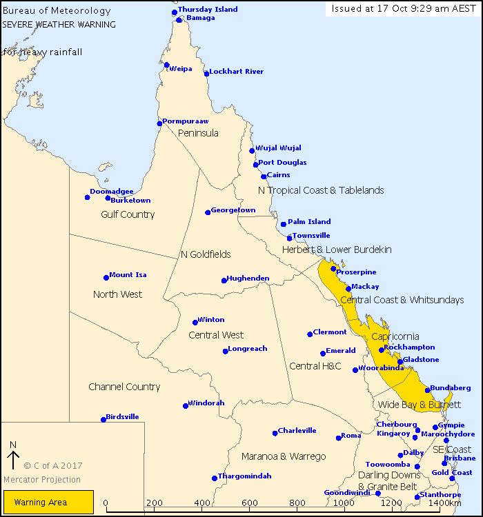
For people in Central Coast and Whitsundays, Capricornia and parts of Wide Bay and Burnett Forecast Districts.
Issued at 9:29 am Tuesday, 17 October 2017.
Heavy rainfall is likely to occur in coastal areas between Bowen and Hervey Bay during the next 24 hours.
Weather Situation:
A strong upper low lies over central Queensland, which will move northeast towards the tropical coast during the next 24 hours. A surface trough lies off the Wide Bay and Capricornia coast, and is expected to extend back onto the Central Coast overnight tonight.
Areas of heavy rain and thunderstorms, which may lead to flash flooding, are expected to develop in some coastal and adjacent inland areas between Bowen and Hervey Bay during the next 24 hours, chiefly overnight tonight. 6 hourly rainfall totals of 120mm to 180mm are possible.
Gusty conditions will continue in exposed areas, but damaging gusts over 90 km/h are no longer expected.
Severe thunderstorms are possible within the warning area, and separate Severe Thunderstorm Warnings will be issued as necessary.
Locations which may be affected include Bundaberg, Gladstone, Rockhampton, Mackay, Proserpine, Bowen, Fraser Island, Hervey Bay, Yeppoon and Hamilton Island.
Queensland Fire and Emergency Services advises that people should:
* Never drive, walk or ride through flood waters. If it's flooded, forget it.
* Keep clear of creeks and storm drains.
* For emergency assistance contact the SES on 132 500.
 |


No comments:
Post a Comment