
Source: Bureau of Meteorology
Issued at 10:59 am EST on Monday 27 March 2017
Headline:
Debbie becomes a severe category 3 system, expected to intensity further on approach to the north Queensland coast.
Areas Affected:
Warning Zone
Cardwell to St Lawrence including Townsville, Mackay, and the Whitsunday Islands, and inland of Bowen including Charters Towers.
Watch Zone
inland areas between Lucinda and Mackay including Pentland, and Mount Coolon.
Cancelled Zone
None.
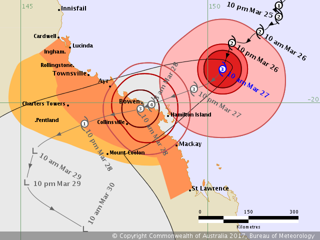
Details of Severe Tropical Cyclone Debbie at 10:00 am AEST:
Intensity: Category 3, sustained winds near the centre of 120 kilometres per hour with wind gusts to 165 kilometres per hour.
Location: within 35 kilometres of 19.1 degrees South 150.4 degrees East, estimated to be 375 kilometres east of Townsville and 250 kilometres east northeast of Bowen.
Movement: south southwest at 7 kilometres per hour.
Severe Tropical Cyclone Debbie has recently strengthened into a category 3 system, and is expected to intensify further as it continues to move west-southwest towards the Queensland coast today. Severe Tropical Cyclone Debbie is forecast to make landfall as a severe tropical cyclone between Ayr and Cape Hillsborough, north of Mackay, on Tuesday morning.
Hazards:
GALES are now occuring about the Whitsunday Islands, and are expected to extend to the exposed coast and islands elsewhere between Ayr and Mackay this morning and early afternoon. GALES could extend to remaining coastal and adjacent inland areas between Townsville and St Lawrence later today before potentially extending further north to Cardwell and further west to inland locations such as Charters Towers, Pentland and Mount Coolon on Tuesday.
DESTRUCTIVE WINDS with gusts over 125 km/h may develop about the exposed coast and islands between Cape Upstart and Mackay during the afternoon. These DESTRUCTIVE WINDS may extend further north along the coast to Townsville overnight and during Tuesday and to adjacent inland areas, including Collinsville, on Tuesday.
The VERY DESTRUCTIVE CORE of tropical cyclone Debbie is forecast to cross the coast between Townsville and Mackay on Tuesday morning with wind gusts potentially to 240 km/h near the centre of the system.
Abnormally high tides are expected to occur along the coast between Proserpine and Mackay on the high tides today.
Residents between Cape Ferguson and Mackay are specifically warned of the dangerous storm tide as the cyclone crosses the coast on Tuesday morning. The sea is likely to rise steadily up to a level well above the normal tide, with damaging waves and flooding of some low-lying areas close to the shoreline as the cyclone approaches the coast on Tuesday. Large waves may also develop along the beachfront. People living in areas likely to be affected by this flooding should take measures to protect their property as much as possible and be prepared to follow instructions regarding evacuation of the area if advised to do so by the authorities.
Areas of heavy rain with the potential to cause severe flash flooding are expected to develop about parts of the northern and central Queensland coast and adjacent inland areas later today and continue through Tuesday. Widespread daily rainfall totals of 200 mm, with isolated falls of 400 mm, are also likely to lead to major river flooding over a broad area next week, and a Flood Watch is current for coastal catchments between Cardwell and Gladstone, extending inland to the eastern Gulf River catchments.
Recommended Action:
People on the Whitsunday Islands should complete preparations quickly and be prepared to shelter in a safe place.
- Boats and outside property should be secured using available daylight hours.
People between Cardwell and St Lawrence, and inland to Collinsville and Charters Towers, should immediately commence or continue preparations, especially securing boats and property.
People inland of Lucinda to Mackay including Pentland and Mount Coolon should consider what action they will need to take if the cyclone threat increases.
- Information is available from your local government
- For cyclone preparedness and safety advice, visit Queensland's Disaster Management Services website (www.disaster.qld.gov.au)
- For emergency assistance call the Queensland State Emergency Service on 132 500 (for assistance with storm damage, rising flood water, fallen trees on buildings or roof damage).
Current Tropical Cyclones
 |


No comments:
Post a Comment