
Source: Bureau of Meteorology
Media: Transmitters serving the coastal and adjacent inland areas between Ayr and Sarina, including the Whitsunday Islands, are requested to USE the Standard Emergency Warning Signal before broadcasting the following warning
TOP PRIORITY FOR IMMEDIATE BROADCAST
TROPICAL CYCLONE ADVICE NUMBER 37
Issued at 6:00 am EST on Tuesday 28 March 2017
Headline:
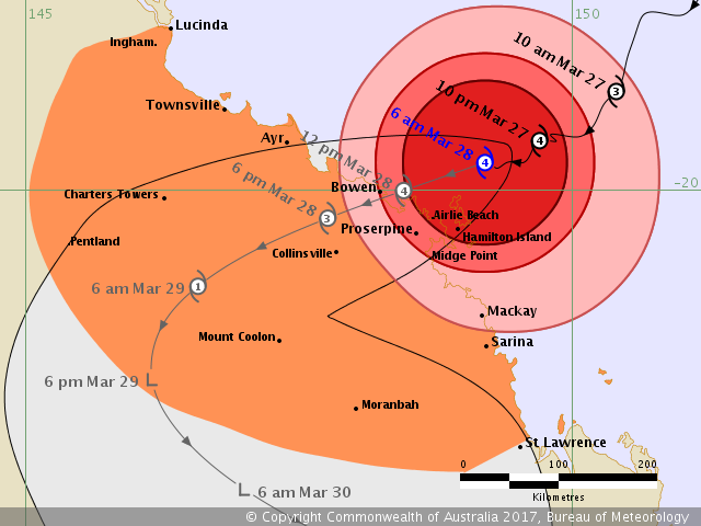
Eye wall of severe tropical cyclone Debbie soon to pass across the Whitsunday Islands.
Areas Affected:
Warning Zone
Lucinda to St Lawrence, including Townsville, Mackay, and the Whitsunday Islands, extending inland to Charters Towers, Mount Coolon, Moranbah, and Pentland.
Watch Zone
None.
Cancelled Zone
None.
Details of Severe Tropical Cyclone Debbie at 6:00 am AEST:
Intensity: Category 4, sustained winds near the centre of 175 kilometres per hour with wind gusts to 250 kilometres per hour.
Location: within 30 kilometres of 19.8 degrees South 149.2 degrees East, estimated to be 105 kilometres east northeast of Bowen and 75 kilometres north northeast of Hamilton Island.
Movement: west southwest at 8 kilometres per hour.
Severe tropical cyclone Debbie is currently a category 4 cyclone and is forecast to make landfall between Ayr and Midge Point late this morning towards midday.
Hazards:
The VERY DESTRUCTIVE CORE of severe tropical cyclone Debbie is now starting to impact the Whitsunday Islands and the centre of the system is forecast to cross the coast between Ayr and Midge Point later this morning towards midday with wind gusts potentially to 260 km/h near the centre.
DESTRUCTIVE WINDS with gusts over 125 km/h are occurring about the coast and islands between Bowen and Midge Point, including Proserpine, and will extend further along the coast to areas between Ayr and Sarina during this morning or afternoon. These DESTRUCTIVE WINDS may extend further north along the coast to Townsville and to adjacent inland areas, including Collinsville, Charters Towers, and Mount Coolon during the day today. It is possible that these DESTRUCTIVE WINDS may extend further south along the coast to St Lawrence today.
GALES are now occurring about the coast and island between about Home Hill and Sarina. These GALES are expected to extend to the remaining coastal and island areas between Townsville and St Lawrence later today. GALES could potentially extend further north to Lucinda and further inland to locations such as Charters Towers, Pentland, Mount Coolon, and Moranbah this afternoon and tonight.
Residents between Ayr and St Lawrence are specifically warned of the dangerous storm tide as the cyclone crosses the coast. The sea is likely to rise steadily up to a level which will be significantly above the normal tide, with damaging waves, strong currents and flooding of low-lying areas extending some way inland. People living in areas likely to be affected by this flooding should take measures to protect their property as much as possible and be prepared to follow instructions regarding evacuation of the area if advised to do so by the authorities.
Areas of heavy rain with the potential to cause severe flash flooding have developed around the Central Coast and Whitsundays district and are expected to spread to other parts of the northern and central Queensland coast and adjacent inland areas today. Widespread daily rainfall totals of 150 to 250 mm, with isolated event totals of 500 mm, are also likely to lead to major river flooding over a broad area this week, and a Flood Watch is current for coastal catchments between Rollingstone and Gladstone, extending inland to the Upper Flinders, Thomson and Barcoo catchments.
Recommended Action:
- People in the path of the very dangerous cyclone should stay calm and remain in a secure shelter - above the expected water level - while the very destructive winds continue.
- Do not venture outside if you find yourself in the eye of the cyclone - very destructive winds from a different direction could resume at any time.
- Follow the evacuation advice or directions of Police, Emergency Services personnel and local authorities.
People elsewhere along the coast between Lucinda and St Lawrence and adjacent inland areas, including Collinsville, Charters Towers, Pentland and Moranbah, should complete preparations quickly and be prepared to shelter in a safe place.
- Boats and outside property should be secured.
- For cyclone preparedness and safety advice, visit Queensland's Disaster Management Services website (www.disaster.qld.gov.au)
- For emergency assistance call the Queensland State Emergency Service on 132 500 (for assistance with storm damage, rising flood water, fallen trees on buildings or roof damage)..
Current Tropical Cyclones
 |


No comments:
Post a Comment