
QLD Tropical Cyclone Warning: Bowen to Double Is Point & inland to Blackwater, Moura, Biloela, Monto |  | Source: Bureau of Meteorology
TROPICAL CYCLONE ADVICE NUMBER 11
Issued at 4:00 pm EST on Thursday 19 February 2015
Headline:
Marcia now category 3. This very dangerous cyclone is continuing to intensify as it approaches the coast.
Areas Affected:
Warning Zone
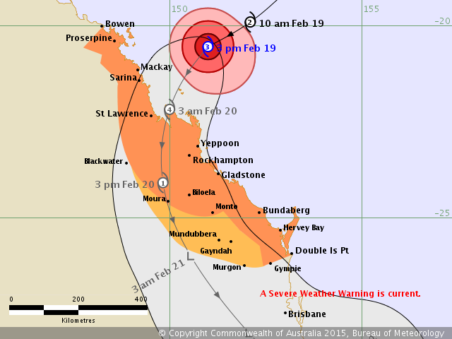
Bowen to Double Island Point extending inland to Blackwater, Moura, Biloela, and Monto
Watch Zone
Adjacent inland areas between Bundaberg and Double Island Point, extending inland to include Mundubbera, Gayndah, and Murgon
Cancelled Zone
None.
Details of Severe Tropical Cyclone Marcia at 3:00 pm EST:
Intensity: Category 3, sustained winds near the centre of 155 kilometres per hour with wind gusts to 220 kilometres per hour.
Location: within 20 kilometres of 20.5 degrees South 151.0 degrees East, estimated to be 290 kilometres north of Yeppoon and 200 kilometres east northeast of Mackay.
Movement: west southwest at 26 kilometres per hour.
Severe tropical cyclone Marcia continues to move southwest towards the Queensland coast. The cyclone is expected to maintain this motion through to landfall between St Lawrence and Gladstone early on Friday. This very dangerous cyclone is now at category 3 intensity and continuing to intensify extremely rapidly. It is now forecast to reach category 4 by landfall.
A separate Severe Weather Warning is current for areas south of Double Island Point and west to the Great Dividing Range.
Hazards:
The VERY DESTRUCTIVE CORE of severe tropical cyclone Marcia, with gusts to 260 km/h, is expected to cross the coast between St Lawrence and Gladstone early on Friday morning.
DESTRUCTIVE WINDS are expected to develop about coastal and island communities between Mackay and Burnett Heads tonight.
GALES are expected to develop about coastal and island communities between Bowen and Double Island Point this evening, and extend inland to areas including Blackwater, Moura, Biloela, and Monto overnight and Friday.
Abnormally high tides will be experienced today and Friday with water levels expected to rise above the highest tide of the year on the high tide.
Coastal residents between St Lawrence and Double Island Point are specifically warned of the dangerous storm tide as the cyclone crosses the coast. The sea is likely to rise steadily up to a level well above the normal tide, with damaging waves and flooding of some low-lying areas close to the shoreline. People living in areas likely to be affected by this flooding should take measures to protect their property as much as possible and be prepared to follow instructions regarding evacuation of the area if advised to do so by the authorities.
Dangerous surf is expected about exposed beaches south of Sandy Cape.
Thunderstorms are expected to develop near the coast between St Lawrence and Hervey Bay ahead of tropical cyclone Marcia crossing the coast. These thunderstorms may produce localised areas of destructive wind gusts in excess of 125 km/hr about coastal and island communities.
Heavy rainfall will develop about coastal and island communities between Mackay and Double Island Point today, particularly over areas to the south of the system. A Flood Watch is current for the area.
Recommended Action:
People between Bowen and Double Island Point should complete preparations quickly and be prepared to shelter in a safe place.
- Boats and outside property should be secured [using available daylight hours/before nightfall].
- For cyclone preparedness and safety advice, visit Queensland's Disaster Management Services website (www.disaster.qld.gov.au)
- For emergency assistance call the Queensland Fire and Emergency Service (QFES) on 132 500 (for assistance with storm damage, rising flood water, fallen trees on buildings or roof damage).
Current Tropical Cyclones
EWN Radar & Alerts Map | QLD Facebook Alerts | Twitter Alerts | |


No comments:
Post a Comment