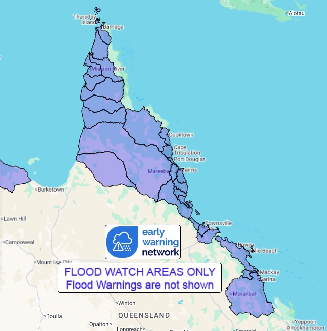
| | QLD Flood Watch: North Tropical Coast & parts of Cape York, Central Coast, Capricornia and Carpentaria catchments | Source: Bureau of Meteorology
Issued at 12:46 pm AEST on Wednesday 4 March 2026
Flood Watch Number: 3
RIVER LEVEL RISES AND FLOODING POSSIBLE ACROSS THE FLOOD WATCH AREA FROM THURSDAY
The monsoon trough lies over the southern Cape York Peninsula and will linger throughout the week. Tropical low 29U has formed along the monsoon trough in the northern Coral Sea. This low is expected to move southwest towards the Queensland coast from Wednesday night, and is expected to cross North Queensland cost during Friday. A second tropical low 31U has developed in the southern Gulf of Carpentaria and will remain slow moving. These systems may result in flooding across parts of the Western Cape Peninsula and North Tropical Coast from Friday.
Areas of moderate rainfall are possible during Wednesday across the flood watch area. From Thursday and into the weekend the risk of heavy falls increases depending on the movement and development of the low pressure system (29U).
Catchments across the Flood Watch area are wet to saturated with recent rainfall. Further rainfall may result in rapid river level rises and flooding. Disruption to transport routes are likely across parts of the Flood Watch area.
Catchments likely to be affected include:
Normanby River
Endeavour River
Daintree River
(including Bloomfield River)
Mossman River
Barron River
Mulgrave and Russell Rivers
Johnstone River
Tully River
Murray River
Herbert River
Black River
Ross and Bohle Rivers
Haughton River
Don and Proserpine Rivers
Pioneer River
Connors, Isaac and Styx Rivers and Plane Creek
Settlement Creek
Staaten River
Mitchell River
(moderate flooding occurring in Magnificent Creek)
Coleman and Edward Rivers
Holroyd and Kendall Rivers
Archer and Coen Rivers
Watson River
Embley and Mission Rivers
Wenlock River
Ducie, Jackson and Skardon Rivers
Jardine River
For the latest flood and weather warnings see www.bom.gov.au/weather-and-climate/warnings-and-alerts
For the latest rainfall and river level information see www.bom.gov.au/australia/flood
Safety Advice:
Don't drive, walk, swim or play in floodwater because it is dangerous.
Stay away from flooded drains, rivers, streams and waterways.
Obey road closure signs. Plan ahead so you don't drive on flooded roads.
Check the ABC and local media for updates. The situation can change quickly, so stay informed.
For local emergency management warnings and advice visit www.disaster.qld.gov.au/warnings.
For emergency assistance call SES on telephone number 132 500. In life-threatening emergencies, call 000 (triple zero) immediately
Rainfall and River Conditions Map
 |


No comments:
Post a Comment