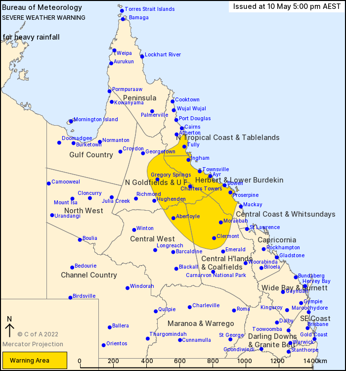
Source: Bureau of Meteorology
For people in Herbert and Lower Burdekin, Central Coast and Whitsundays and parts of North Tropical Coast and Tablelands, Northern Goldfields and Upper Flinders, Central Highlands and Coalfields and Central West Forecast Districts.
Issued at 5:00 pm Tuesday, 10 May 2022.
HEAVY RAINFALL ACROSS THE INTERIOR, DEVELOPING OVER THE NORTHEAST TROPICS WITH INTENSE FALLS POSSIBLE.
Weather Situation: An unseasonably moist northeasterly flow extending across Queensland is combining with a significant upper trough and associated low over central Australia. A surface trough over the northern interior may deepen into a low over the Herbert and Lower Burdekin and quickly move offshore overnight tonight and through Wednesday morning. Uncertainty exists with the development and movement of the surface low during this period, however, it's becoming increasingly more likely that heavy rainfall that reaches severe thresholds will remain north of Mackay.
HEAVY RAINFALL which may lead to FLASH FLOODING is forecast to continue over parts of the Herbert and Lower Burdekin, Central West and Central Highlands and Coalfields for the remainder of the day. Six-hourly rainfall totals between 60 to 100 mm are likely.
Locally INTENSE RAINFALL which may lead to DANGEROUS AND LIFE-THREATENING FLASH FLOODING is also possible with thunderstorms during this period over southeastern parts of the Northern Goldfields and Upper FLinders. Six-hourly rainfall totals up to 150mm are possible.
HEAVY RAINFALL which may lead to FLASH FLOODING is forecast to continue over parts of the North Tropical Coast and Herbert and Lower Burdekin, then extend southeastward over the Central Coast district during Wednesday morning. Six-hourly rainfall totals between 100 to 150 mm are likely, reaching up to 200 mm about the northeast tropical coast.
Locally INTENSE RAINFALL which may lead to DANGEROUS AND LIFE-THREATENING FLASH FLOODING is also possible with thunderstorms during this period over coastal communities between Tully and Proserpine. Six-hourly rainfall totals in excess of 200mm are possible.
A separate Severe Thunderstorm Warning will be issued if very dangerous thunderstorms with intense rainfall are detected.
Flood Warnings and a Flood Watch are current for catchments across much of tropical and inland Queensland. See http://www.bom.gov.au/qld/warnings/ for more information.
Locations which may be affected include Clermont, Proserpine, Charters Towers, Bowen, Townsville, Palm Island, Moranbah, Collinsville, Hamilton Island, Ingham, Innisfail and Lucinda.
Significant rainfall observations include:
156 mm at Carisbrooke Station (southwest of Winton) in 24 hours to 9am.
114 mm at Kirby in 24 hours to 9am with 72 mm in the 3 hour period to 11.45pm
191 mm at Mourilyan Mill since 9am
Queensland Fire and Emergency Services advises that people should:
* Never drive, walk or ride through flood waters. If it's flooded, forget it.
* Keep clear of creeks and storm drains.
* For emergency assistance contact the SES on 132 500.


No comments:
Post a Comment