QLD Severe Weather Warning: Damaging Winds & Heavy Rain
Source: Bureau of Meteorology
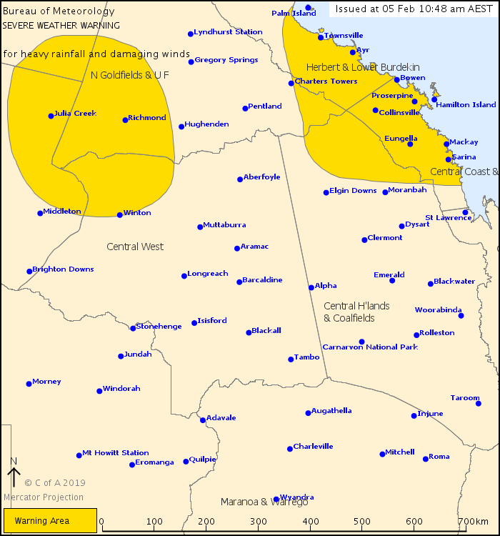
For people in Central Coast and Whitsundays and parts of Gulf Country, Northern Goldfields and Upper Flinders, Herbert and Lower Burdekin, North West, Central Highlands and Coalfields and Central West Forecast Districts.
Issued at 10:48 am Tuesday, 5 February 2019.
Risk of heavy rainfall remains between Paluma and Sarina and adjacent inland, and also over the northwestern interior.
Weather Situation: A deep tropical low, located about 180 kilometres north of Cloncurry, extends a vigorous monsoon trough eastward through about Ingham. Both features are currently slow moving.
EAST COAST AND ADJACENT INLAND AREAS:
Areas of heavy rainfall with six-hourly totals between 150mm to 200mm are likely within the warning area today and/or overnight. Concentrated areas of intense rainfall with totals up to 300mm are possible, particularly with bands of thunderstorms.
Heavy rainfall is most likely to occur in areas south and east of Ayr, however the threat of severe thunderstorms with heavy, potentially intense rainfall remains a risk for areas to the north and west including the Townsville area.
Damaging wind gusts up to 90km/h are possible in coastal areas south of Bowen.
Locations which may be affected include Mackay, Townsville, Bowen, Ayr, Palm Island, Rollingstone, Proserpine, Collinsville, the Whitsunday Islands and Sarina.
A number of major Flood Warnings are current for this region - please refer to http://www.bom.gov.au/qld/warnings/
24 hour falls to 9am Tuesday:
Paluma 384mm
Upper Bluewater 364mm
Rollingstone 240mm
Upper Finch Hatton 208mm
Clarke Range 191mm
NORTHWESTERN INTERIOR:
Heavy rainfall, which may lead to flash flooding, is likely to continue across the northwestern interior. Six-hourly rainfall totals of 70mm to 140mm are possible.
Locations which may be affected include Julia Creek, Richmond and Winton.
Flood Warnings are current for this region - please refer to http://www.bom.gov.au/qld/warnings/
24 hour falls to 9am Tuesday:
Gilliat River 325mm
Julia Creek Airport 233mm
Brinard Station 231mm
Queensland Fire and Emergency Services advises that people should:
* Move your car under cover or away from trees.
* Secure loose outdoor items.
* Seek shelter, preferably indoors and never under trees.
* Beware of fallen trees and powerlines.
* Never drive, walk or ride through flood waters. If it's flooded, forget it.
* Keep clear of creeks and storm drains.
* For emergency assistance contact the SES on 132 500.
 |


 Help | Log In | Alerts Map | Register | Unsubscribe
No comments:
Post a Comment